Climate Variability and its Impact on Extreme Events
Tropical Cyclone Intensity, Structure and Associated Rainfall
Tropical cyclones (TCs) are devastating weather systems for the coastal region. The damages from a landfalling TC come from its strong winds, heavy rainfall and storm surges, which are highly related to its intensity and structure. The following figure shows a typical TC structure .
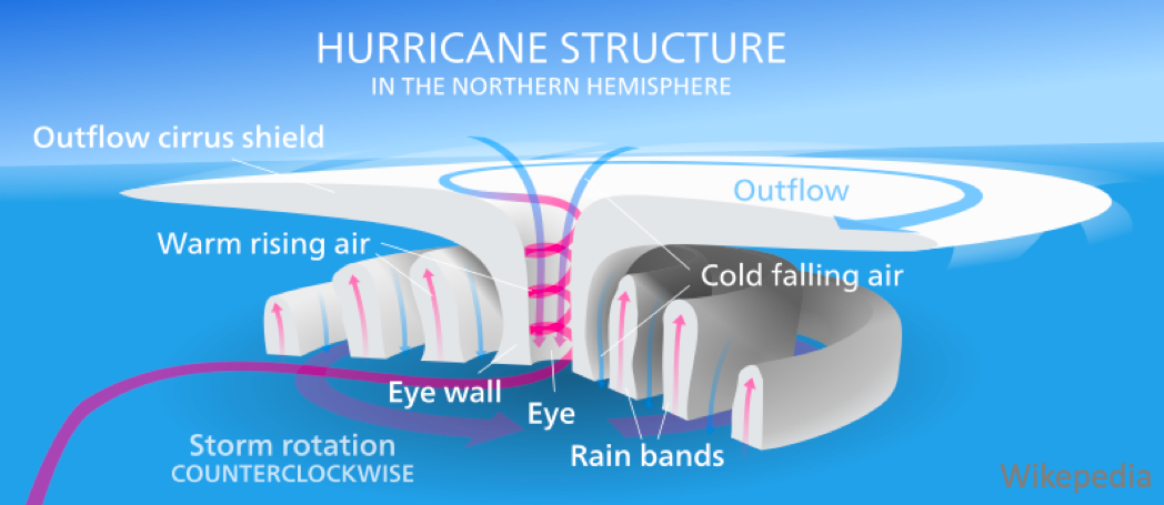
Previous studies have explored both the internal and external factors influencing TC intensity and structure. The related characteristics of TCs include intensity, size, radial profile of tangential winds and intensification rate.
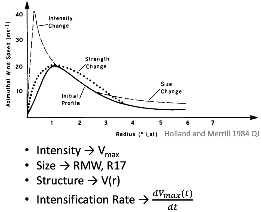
The figure on the left shows a typical TC radial profile of tangential winds, the evolution of TC wind field can be featured by changes in its intensity, size and 'strength'. The relationship between TC intensity and structure is mostly studied from statistical analysis and model simulations. However, a clear quantitative analysis with physical understanding to connect the intensity and structure together is still missing. I'm interested in studying the TC structure and intensity from all aspects.
Tropical Cyclone Axisymmetric Theory
One of my approaches is to use TC theories as a guidance to find the relationship among those dynamically related parameters. The various tropical cyclone axisymmetric theories, developed based on the three basic assumptions of gradient wind balance, hydrostatic balance and slantwise moist neutrality, are suitable for exploring TCs during the rapid intensification and steady-state stages. Though there are discrepancies between theories and real TCs, it is also interesting to see how much the theories can explain the results from observations and model simulations.
Tropical Cyclone Climatology
Modeling studies have explored the effects of Coriolis parameter, environmental moisture and sea surface temperature as well as initial vortex sizes on TC's struture and intensity. It would be interesting to investigate the observational data sets to verify these results and conclude the TC characteristics in the real world and analyze the climate model forecasts for the future climate scenarios.
Tropical Cyclone Rainfall
Tropical cyclone associated rainfall is receiving more attention recently. It is found that not all TCs causing heavy flooding are intense storms, e. g., Hurricane Florence (2018). If we can find a good indicator for the rainfall rates and distributions from the associated TC characteristics, it will be beneficial for risk management and insurance companies.
Dynamics and Predictability of Tropical Cyclones under Different Environmental Conditions
The prerequisite for the axisymmetric tropical cyclone theory limits its application on early stage/weak TCs, which are usually asymmetric and have loosely organized convections. It has been shown that weak tropical cyclones are vulnerable to the hostile environment (e.g., vertical wind shear), which can lower the predictability of tropical cyclogenesis and rapid intensification onset.
Intrinsic and Practical Predictabilities of Tropical Cyclones under Vertical Wind Shear
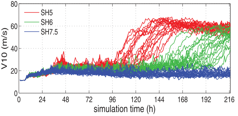
The figure on the left (adapted from Tao and Zhang 2015) exhibits the extremely large uncertainty in RI onset times given the modest uncertainty in environmental vertical wind shear (5 - 7.5 m/s) and the unnoticeble initial moisture perturbations in the boundary layer, which presents the challenges associated with both the practical and intrinsic predictabilities of tropical cyclones. This large spread in RI onset times is attributed to the moist convection, of which the chaotic nature introduces the small-scale errors at first and gradually influences the storm-scale circulations.
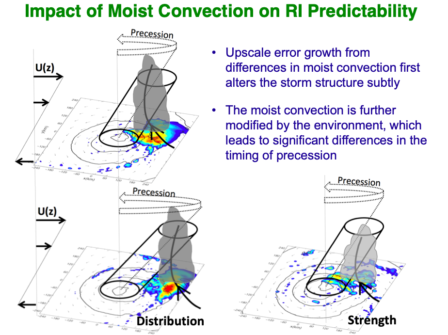
As indicated in the schematic diagrams on the left, the upscale error growth from small differences in the moist convection alters the storm structure, which in turn changes the distribution and strength of the moist convections. Other environmental factors, like environmental moisture and sea surface temperature, can also affect the predictability of TCs through further modifying the moist convections. Generally speaking, higher sea surface temperature and moister environment are conducive to the TC development. The resilience of TCs in the hostile environment should be considered with all factors.
Effect of Environmental Shear, Sea-Surface Temperature, and Ambient Moisture on the Formation of Tropical Cyclones
Environmental factors influence tropical cyclone development through changing its moist convections and hence diabatic heating. Generally speaking, a hostile environment hinders the spinup of a tropical cyclone while a friendly environment aids its development. The figure below (adapted from Tao and Zhang 2014) shows the effect of vertical wind shear and sea surface temperature on the rapid intensification onset.
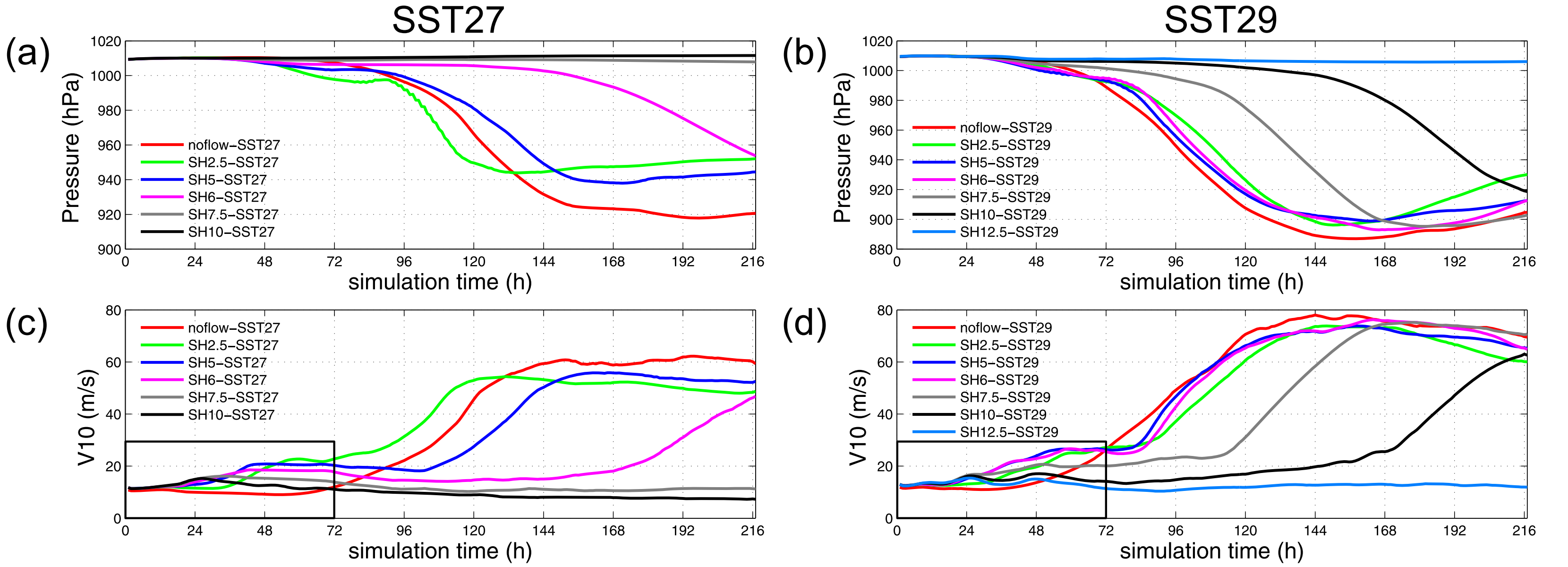
The larger environmental vertical wind shear leads to the longer time before the onset of rapid intensification, primarily because of the longer time needed for the precession and alignment processes. Given the same magnitude of vertical wind shear, the higher sea surface temparature can help reduce the tilt magnitude and therefore shorten the RI onset time. In addition, the critical value of shear magnitude increases, and a tropical cyclone can develop in a more hostile environmental shear.
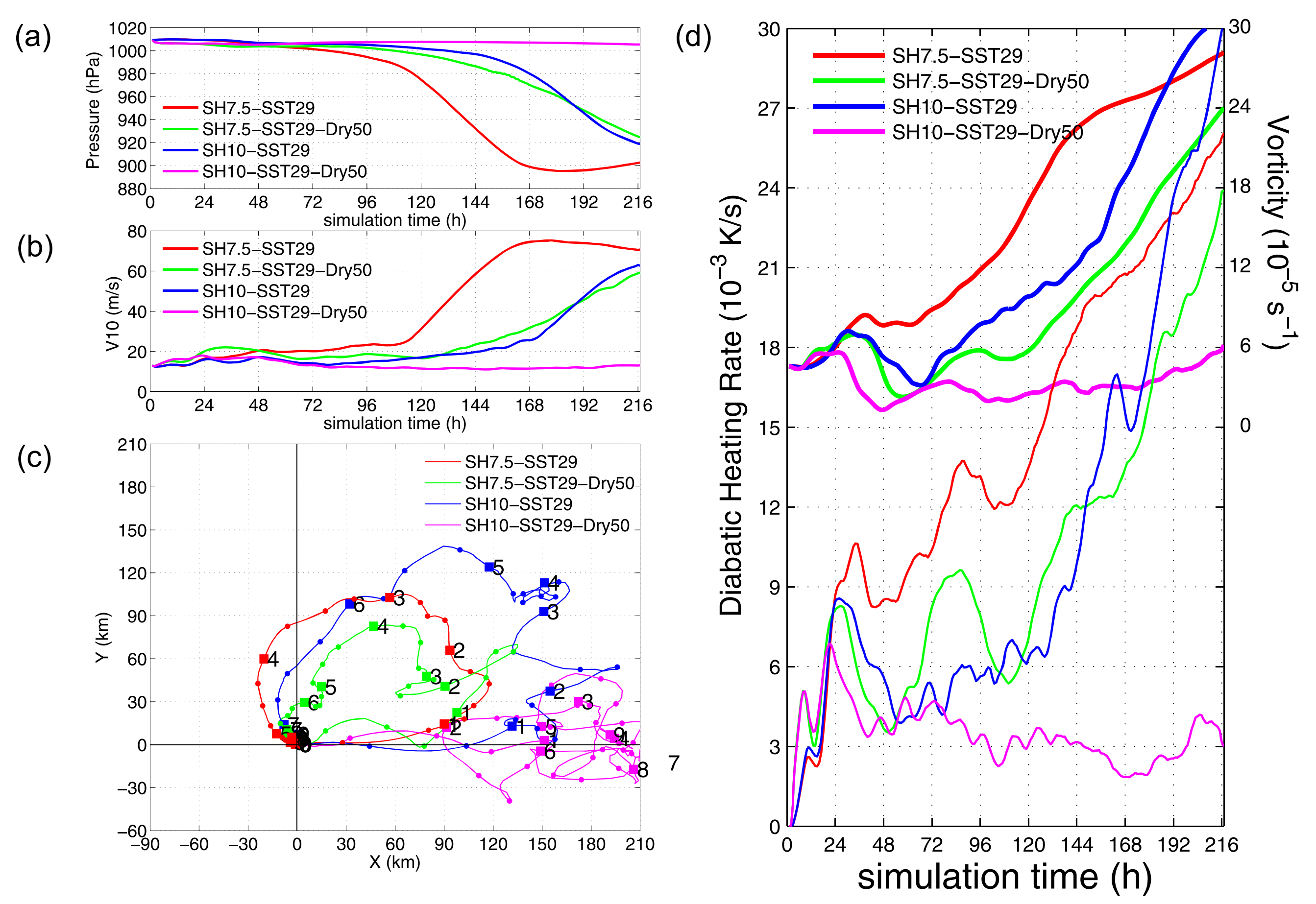
The effect of dry air is usually negative to the development of a tropical cyclone (figure above, adapted from Tao and Zhang 2014). The primary circulation is weakened by the dry air through reducing the diabatic heating rate, which makes it harder for the vortex column to precess and align.
Evolution of Dynamic and Thermodynamic Structures before and during Rapid Intensification of Tropical Cyclones
The TC rapid intensification (RI) onset has long been a hard problem for operational forecastings. Besides improving the model skills, a better understanding of the dynamic and thermodynamic features behind RI onset is also needed. The study by Tao and Zhang (2019) explored the spatial and temporal changes in tropical cyclone (TC) thermodynamic and dynamic structures before, near, and during rapid intensification (RI) under different vertical wind shear conditions.
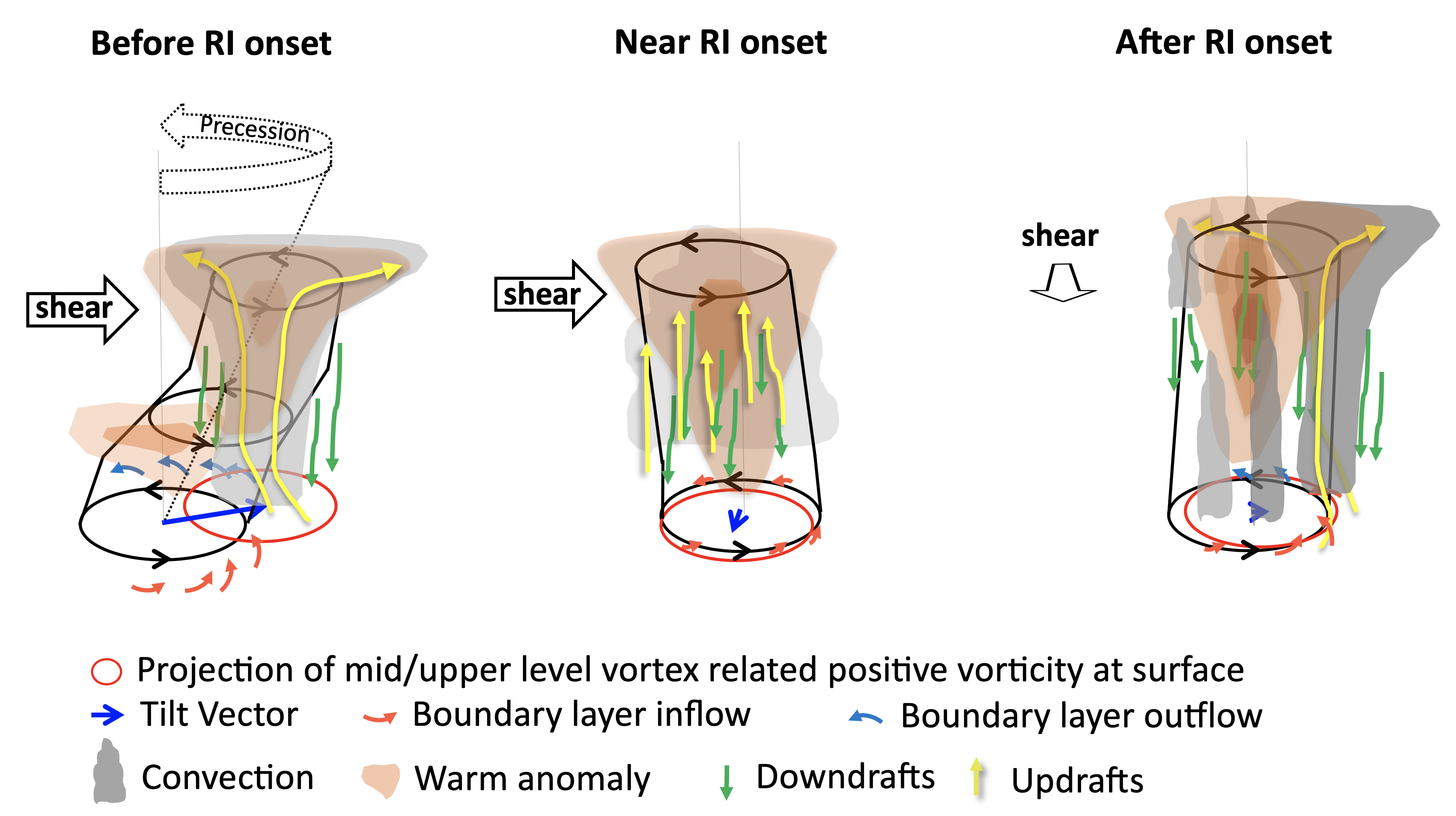
As shown in the schematic diagram above, the vortex alignment under environmental vertical wind shear is a necessity to establish the structure of secondary circulation with an eye. From a thermodynamic perspective, the RI onset is the time when the upper-level warm core aligns with the surface center, which changes the static stability of the atmosphere and more efficiently lowers the surface minimum sea pressure. Dynamically, it is the time when entire vortex column aligns and can initiate an efficient secondary circulation.